Website · Free · Every US city and national park
Bugmap
What’s buzzing in your backyard?
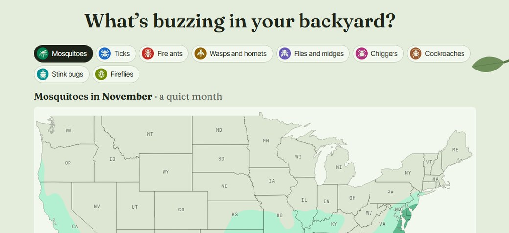
Pick a bug and a month and see where it’s out across the US, then tap any spot or search a ZIP code for that place’s whole year: which months, which hours, and how the weather drives it.
Free · No account · Runs in your browser
About the project
What is Bugmap?
Are mosquitoes bad here in June? When do fireflies come out? When is tick season in my state? Bugmap answers those for nine kinds of bugs, in 383 US metro areas and 62 national parks, seashores and lakeshores.
Every page shows a typical year: when the season starts and ends, the busiest months, the hours bugs are out, and the temperature, rain and snow behind it.
So it tells you when bugs are usually out, not how bad they are this week.
How it works
How to use Bugmap
- Pick a bug and a month. On the home map, the colours show where that bug is active.
- Tap a spot or search. Tap anywhere on the map, or search a town or ZIP code, for that spot’s year.
- Go deeper. Open a city, park or state page for the month-by-month and hour-by-hour detail.
What Bugmap covers
| Covers | Detail |
|---|---|
| Bugs | Mosquitoes, ticks, fire ants, wasps and hornets, flies and midges, chiggers, cockroaches, stink bugs, fireflies |
| Cities | 383 US metro areas |
| Parks | 62 national parks, seashores and lakeshores |
| Time | Every month and hour of a typical year |
Bugmap shows a typical year from 1991–2020 climate records. It is not a forecast.
What's in it
Features
- A map for every bug and month. Pick any bug and any month, then tap any spot for a readout of that place.
- City, park and state pages. Each has a season calendar, an hour-by-hour chart and the local weather.
- Mosquitoes, split by kind. The ones in town and the ones in the woods, with how much of each to expect.
- Mountain charts for parks. How the season changes with elevation.
- A field guide for each bug. What it looks like, where it lives and what to do about it.
- Art that changes with the region. Cactus and agave in the Southwest, palmetto and magnolia in the Southeast, ferns and firs in the Pacific Northwest, aspen and columbine in the Rockies.
Behind the product
How Bugmap was made
Bugmap starts from 30 years of climate records (PRISM’s 1991–2020 normals), which a data pipeline I wrote turns into temperature, rain and snow for every place on the map. Each bug’s season is modelled from that weather, then checked against field data: mosquito and tick trap counts from the National Ecological Observatory Network, the CDC’s tick surveillance and sightings logged on the Global Biodiversity Information Facility.
It shows a typical year, never a forecast, and it shows when bugs are active, never the risk of getting sick. Each bug is on its own scale rather than ranked against the others.
I built it on my own. The map pictures are drawn ahead of time so pages load fast, and the wordmark was outlined by hand, with a second ear added to the g so it reads as a little bug’s head.
FAQ
Bugmap: frequently asked questions
What is Bugmap?
A free website that shows when mosquitoes, ticks, fire ants, wasps and hornets, flies and midges, chiggers, cockroaches, stink bugs and fireflies are active in 383 US metro areas and 62 national parks, seashores and lakeshores, by month and by hour, in a typical year. It’s at bugmap.info.
Is Bugmap a forecast?
No. It shows a typical year from 30 years of climate records, so it answers “when are bugs usually out here?”, not “how bad is it this week?”
Does it tell me about disease risk?
No. It shows when bugs are active, not the chance of getting sick. For health questions, see the CDC or your state health department.
Is Bugmap free?
Yes, and there’s no account.
Where does the data come from?
Climate records from PRISM, mosquito and tick sampling from the National Ecological Observatory Network, the CDC’s tick surveillance, and sightings from the Global Biodiversity Information Facility. Bugmap’s How we know page has the details.
Keep exploring
More things I’ve built
Bring bug spray
Or don’t. We’ll tell you when.
Bugmap is free, needs no account and works in your browser.